Showing posts with label Cycle Tour. Show all posts

Monday, January 27, 2014

Mayne Island by Bike

The Gulf Islands are one of British Columbia's  best kept secrets.  Just a short ferry ride from the mainland, there is so much to explore and discover and cycling is the way to do it.

Waiting to board the ferry at Tsawwassen
Nothing beats the January blahs better than a weekend getaway to Mayne Island.  Our friends (who shall remain nameless to protect the innocent) invited us for a weekend at their cottage.  We began early in the morning cycling to the Tsawwassen ferry terminal.  It was a spooky ride as the fog was dense.  You always feel so vulnerable on your bike while riding in the fog, yet at the same time your senses seem to come alive.  We rode cautiously, listening to the call of the eagles and watching everything come to life.  The air was crisp and cool and as the fog began to lift we were treated to a wonderful sunrise.  It felt so good to be back on the bikes....mindlessly pedalling through the fog!

The ferry makes a quick stop at Galiano Island (another great bike destination) and then proceeds on to Mayne Island.  As you approach the dock at Mayne Island you leave the hustle and bustle of the city behind you and either consciously or unconsciously begin to adapt to "Island time" The cycling on Mayne is wonderful...although be prepared for a few hills and cycle in single file as there are no shoulders.  Having said that, the drivers are thoughtful and give plenty of room when passing.


Beautiful views are plentiful


Snowdrops remind us that spring is around the corner

We cycled from the ferry to the cottage...which is truly a bit of heaven on earth.  The cottage reflects the hosts...warm & friendly...like a big hug.  It features panoramic ocean views - in fact, you can quickly lose track of time and also the will to move as you sit by the wood burning stove and gaze at the ocean.


There is much to do on Mayne - beautiful parks including one of the Gulf Islands National Park Reserves at Bennet Bay, beach combing, artists galleries and to our surprise a Japanese Garden.  This weekend we chose to hike to  the spectacular viewpoint on Mount Parke.  We were thrilled at the panoramic view, yet couldn't stay for long as we were losing daylight.

Mayne residents enjoying an all you can eat lunch buffet


The weekend went all too quickly and we left feeling rejuvenated and ready to return to explore more of the Island...next time by kayak?

Giggle of the day:

The weekend was full of laughter and great conversation.  Giggles were plentiful.  Here are a few:

While in Minor's Bay we decided to pop in to the local grocery store to pick up some lunch meat.  As we waited for service, a friendly voice came on the loud speaker and said,  "Shelly to the deli."  We burst in to laughter and thanked Shelly for the giggle and for the shaved ham...of course!

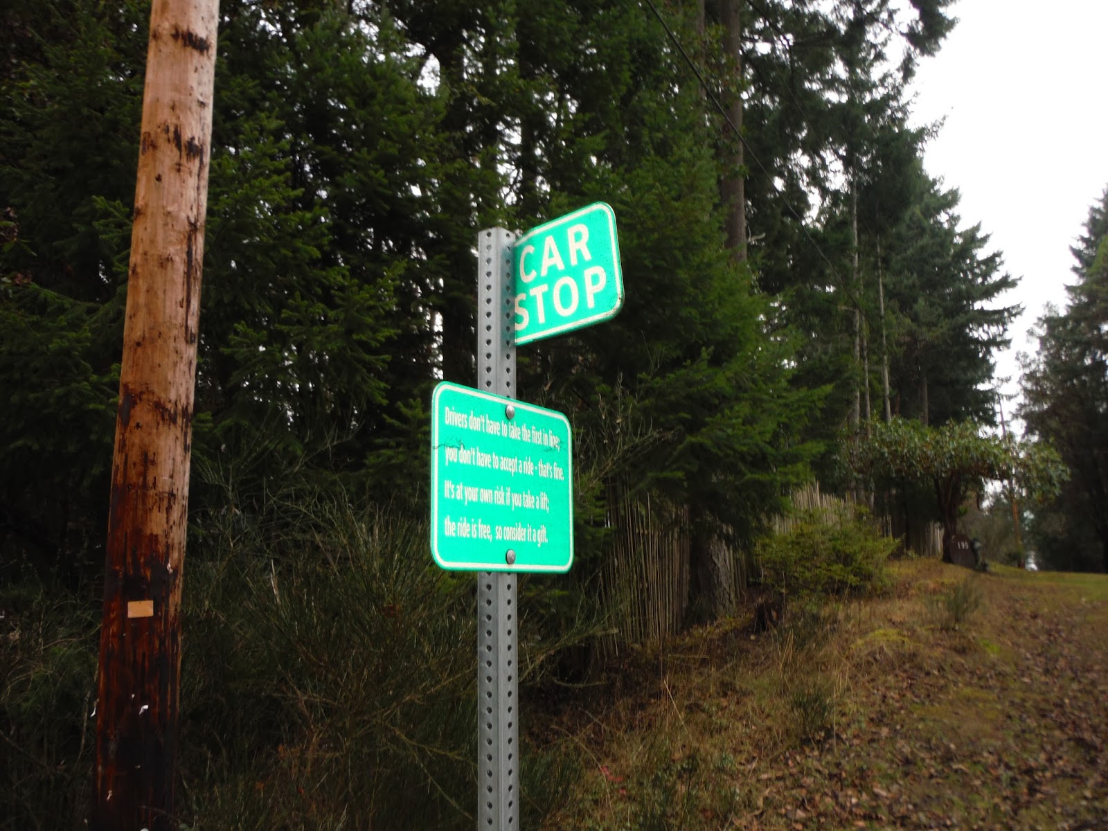
Car stops - The island features numerous car stops....a sign of community and of days gone by.  The signage both inspires and amuses!  Here's the scoop:


You are welcome to use our 25 Mayne Island Car Stops. This is free, voluntary, alternative transportation that is environmentally and community-friendly. We encourage drivers to share the ride, reducing fuel consumption and our ecological footprint. We encourage pedestrians who need a lift — including those arriving by ferry or boat — to try waiting at a Car Stop, and be open to the generosity of drivers. (Unlike a bus, there's no regular schedule; like a bus, you trust the driver.)
Car Stops signs are green and white road signs located at pullouts all around Mayne. They indicate the locations where drivers may expect to see passengers seeking a ride. They are two-way stops, so if you're standing there, indicate with your hand which way you're heading, and if you cross the street, be careful.

THE RULES:
  • Drivers don't have to take the first in line;
  • you don't have to accept a ride - that's fine.
  • It's at your own risk if you take a lift,
  • the ride is free, so consider it a gift.
CAR STOP - 

Last, but not least, as we rode back to the ferry dock to begin the trip home, we passed numerous Islanders on foot, with backpacks, suitcases, dollies all trudging along the main road back to the ferry.  It tickled us as we passed young and old on the "Mayne Island Pilgrimage."


Mayne Island "pilgrams" wait to disembark ... until we ride again!

Map and Route Tips:

BC Ferries - Schedules and Route information

Tuesday, October 29, 2013

Cycling the BC Parkway to Central Valley - Graffitti, cowboys and spawning salmon!

Exploring the lower mainland by bike is always a treat, and today was no exception.  We decided to begin our trip at the New Westminster Quay and head into Vancouver via the BC Parkway.  This multi-use urban trail is 26 kilometers long and follows the Expo Skytrain line from Surrey, to New West, South Burnaby and into Vancouver.

 The heavy fog that had blanketed the lower mainland for days magically lifted and we were treated to a bright, crisp, sunny fall day.  The colours of the leaves were magnificent and we enjoyed the sound of them crunching beneath our tires as we pedaled along.

View of the Fraser River near New Westminster Quay
Signs on dedicated bike paths....AWESOME!


It was another day of contrasts - industry along the river and rail lines, graffiti, high end condos and homelessness, yachts, shopping malls, sports fields, restaurants, bars and people, people, people!  We saw it all.  It truly is remarkable that in a few short kilometres a cyclist travelling along the urban trails can pass through numerous municipalities and experience both the highs and the lows of our communities.

Anything in a size seven?

Brilliant Fall colours

Approaching downtown Vancouver

Was there a George Clooney sighting here?

We cycled along the waterfront to English Bay and Stanley Park enjoying the Sunday morning sights and sounds.  As we approached Canada Place, Rob noticed DeDutch Pannekoek House conveniently located right on the seawall.  The breakfast menu seemed to have his name on it so we had to stop.  Rob simply could not MASH one inch further.  It was such a warm day that we were able to sit outside on the patio and enjoy our breakfast as we watched the float planes take off and land.

We decided to experiment and try a new route out of downtown.  We followed the Dunsmuir bike lane to Adanac and then began the climb out of Vancouver toward Simon Fraser University.  We were confident that we would be able to find our way back to the Central Valley Greenway....and after a few stops and starts that's exactly what we did!

Heading uphill towards Simon Fraser on the Frances Union Bikeway

The highlight of the day was on the Central Valley Greenway. As we entered the park there was a sign warning folk to be cautious as there was a bear in the area.  We thought that was a bit unusual...after all we were in the middle of Burnaby.  However,  as we pedaled along we could hear splashing coming from the stream below and quickly deduced why bears might be hanging out!  The salmon were putting on a show.  We hopped off our bikes and made our way down to the stream to watch the epic battle.  Salmon were coming up the stream in waves as they fought their way against the current.  It was inspiring to watch.  Credit to the restoration crew who has been working to restore the habitat!

Salmon fighting their way up Still Creek to spawn


Steps to help the salmon along their way


As usual the day ended far too quickly!  To celebrate the salmon sightings we stopped for a gelato....chocolate of course!  Another perfect day and perfect ride.

Guilt free Gelato break....life is good!

Giggle of the day:

As we came to a red light on Main Street near Science World, a young gentleman pulled up beside us and exclaimed "HOWDY PARTNER!".  He was dressed in full cowboy gear....boots, hat, jeans, vest and sheriff's badge.  (in fairness, we were in downtown Vancouver AND it was the weekend before Halloween).  The young man pulled a 26 ounce bottle of scotch out of his bike basket and asked if we would like a swig.  How generous!  We did notice that half the bottle was missing. We weren't sure if he was on his way to or from the party....or just keeping the party going.  Before we could ask, he gave a hoot and a yippee and was back on his way.  

Map and Route tips:


Burnaby bike Routes  http://www.burnaby.ca/Page386.aspx


Tuesday, July 30, 2013

Not So GranFondo - Horseshoe Bay to Whistler

The route from Vancouver to Whistler is a visual smorgasbord with panoramic views of Howe Sound and the Coast Mountains.  Each year road warriors from around the world flock to Vancouver to cycle the GranFondo.  We decided it was time for us to tackle the route and planned our version of the Not So GranFondo.

Majestic views along the Sea to Sky highway
When asked about our riding style, pace etc., we often joke that we are 'dawdlers". The dictionary defines dawdle as (1)  to spend time idly and (2) to move lackadaisically.  Rest assured there is nothing lackadaisical about the Sea to Sky highway.  The route began at sea level and the trip from Horseshoe Bay took us 102km in distance with - 2400m up, 1750m down and a total end elevation gain of 650m.  To say our legs were tired at the end of the day is an understatement!

The route is suitable for both the road warrior and fellow dawdler.  In fact, we were passed often by those young strapping cyclists, with legs of steel on their road bikes spinning their way to personal best times.  On the other hand we dawdled along and took delight in the views, waterfalls and picnic spots along the way.  The route is also unique as it features a Sea to Sky Cultural Journey aimed at providing a First Nations perspective and cultural awareness.  Interpretive kiosks line the route and are well worth the stop.


We must stress that the Sea to Sky highway is not for the faint of heart.  In the old days, prior to the road upgrades, cyclists would often call this route the Scream and Die highway.  Today the route is more bicycle friendly with nice wide shoulders for the majority of the trip.  Having said that, it is a very busy highway and if you are not comfortable riding in traffic it probably is not for you.  We must also  caution that many a driver mistakes the Sea to Sky for the Indy 500 and it feels quite frightening when these race car drivers pass close to you at speed.  I must confess I uttered a few choice words under my breath as high end cars screamed by me - way to close for comfort!

We began the day in Horseshoe Bay. We parked our vehicle in the long term ferry parking lot.  Horseshoe Bay, especially in the summer, is a bee hive of activity and we took great delight watching families with cars/vans/trailers/motor homes packed to the roof as they waited patiently, and in some cases not so patiently, for their sailings.

Horseshoe Bay, British Columbia

We were excited to see awesome bike route signage as we set off for the Sea to Sky highway.

We do LIKE this!
We were feeling quite confident as we enjoyed the ride out of Horseshoe Bay.  We went through Lions Bay and passed Porteau Cove - a great spot to stop for a picnic and watch the scuba divers in action!  We continued on to Britannia Beach and stopped to savour our morning coffee break at Galileo Coffee Company.  We enjoyed chatting with a fellow from Lions Bay who teased us about the climb ahead.  "You'll make it", he said with confidence.  Strange how those kind words seemed to fill me with doubt!

We set off again towards Shannon Falls.....FANTASTIC!  The falls are the third largest in British Columbia at 335 meters.  They are breathtaking....and we always enjoy stopping here, both to take in the falls, but to also chat with the tourists who flock to the park.  Today we had the pleasure of meeting two young men from Denmark.....they were almost speechless as they set off to scramble up the rocks at the base of the falls.

Trail up to Shannon Falls

We continued past the Stawamus Chief, an extremely popular hiking and climbing spot.  The Chief is a magnificent 700 meter high granite cliff and the view from the top is well worth the hike up. (we will leave the hike for another day!)  As we entered Squamish we decided to stop at the Squamish Adventure Centre to get the inside scoop on local bike trails.  The staff at the Adventure Centre were fantastic and shared with us the plans for the Sea to Sky trail.  When finished the trail will be 180km of non-motorized multi-use trail connecting Squamish to D-Arcy along the Sea to Sky corridor.  What a vision!  We jumped on the trail as we left Squamish on our way to Brackendale.....and then the real climbing began!

Bike friendly trail - Squamish - features bike wash station and tools

To break up the climb we stopped at Brohm Lake for a picnic lunch.  We happily munched and watched the paddle boarders and swimmers enjoy the mountain lake.    We left Brohm Lake refueled and refreshed and continued on our climb to Whistler Village.  We couldn't resist stopping at Brandywine Falls...another spectacular waterfall!  We had the great pleasure of meeting a family from Tasmania....they were drawn to our bikes and had all kinds of questions about cycle touring.  They were travelling across Canada and on their way to try out mountain biking in Whistler....go Tasi's!!!!

Brandywine Falls

We finished the climb to Whistler and connected to the Valley Trail at Function Junction.  It was a welcome relief to get off the highway on to dedicated bike path and meander our way to the village.  Whistler has something for every one and it is always a thrill to enter the village and be surrounded by active folks...hikers, bikers, rafters, paddlers, skiers....not to mention the shoppers, the sightseers and the "partiers!"

Whistler Village
We enjoyed two fabulous nights in Whistler....GLAMPING.  (that is our term for Glamourous camping.  Yes, we left the tent and sleeping bags at home and decided to stay in a hotel!)


Wizard Express Chair - Blackcomb Mountain

View from outside our hotel - Blackcomb

With or without snow....the training must go on!
The only thing better than the view on the way TO Whistler, is the view on the way BACK!!!  The entire return trip is on the ocean side of the road and we found ourselves stopping frequently to take pictures of the rivers, the mountains and the ocean.

Valley Trail passes by the golf course

Fantastic trip back along the river's edge

On the return trip you are afforded the most breathtaking views of the Tantalus Mountain Range - snow capped mountains, the valley, the forest and the river below.  We would include a picture...but, a photo simply does not do it justice.  You must visit and see it for yourself!

It's your turn......
Cheers
Jane and Rob

Giggle of the day:

We arrived in the village, legs spent, sun burnt, hungry and thirsty!  As we entered the village the first thing we saw was the Longhorn Pub...say no more!  We decided a round of Coronas and an order of Nachos was in order.

Sometimes a picture is worth a thousand words......


We parked our bikes and found a seat where we could view the base of the mountain bike trails.  After a couple of cold ones we decided it was time to find our hotel.  We had booked using the Travelocity Top Secret Hotel option.  This is a great tool for those who enjoy pleasant surprises.  You basically choose a location and a price range and roll the dice.  Travelocity books your hotel and you do not learn which hotel you are in, until after you pay! Great fun!  As we finished our beer we decided to figure out exactly where in the village our hotel was located.  Now remember, our legs were completely spent after the day of riding......so to our dismay we learned our hotel was half way up Blackcomb Mountain!  We trudged on up the mountain towards our hotel alternating between cursing and laughing at ourselves!

We are happy to say the climb was well worth it and we enjoyed two fantastic nights at the Coast Blackcomb Inn and Suites.

Entrance to the Coast Blackcomb Inn and Suites

Map and Route Tips:

There is a short stretch between Porteau Cove and Furry Creek where the shoulder becomes quite narrow....exercise caution!

Camping is readily available along the route and there are also lots of options to GLAMP!


View Larger Map